Point Cloud to BIM Conversion Services — Tampa, FL: Precise 3D Scan to Revit Modeling for Reliable Construction Outcomes
We turn high-density 3D laser scan data into intelligent, parametric BIM models that help design teams, contractors, and owners make confident decisions on Tampa projects. Below we explain how field reality capture becomes coordinated Revit models, why that matters for commercial, industrial, and healthcare facilities in the region, and how these digital deliverables reduce rework and speed schedules. You’ll find a clear end-to-end workflow from capture to handover, discipline-specific expectations for architectural, structural, and MEP modeling, plus common file formats and LOD conventions for integration. We also outline local services a Tampa provider can deliver, the precision tools and software we use, and measurable benefits for facility management and historic preservation. Finally, we offer practical next steps so Tampa teams know how to request a consultation and what outcomes to expect from a point-cloud-to-Revit conversion.
What is Point Cloud to BIM and Why is it Essential for Tampa Construction Projects?
Point cloud to BIM is the process of converting registered 3D laser scan data into structured, parametric BIM models that teams use to coordinate design, verify existing conditions, and produce accurate as‑built documentation. The work extracts geometric features from millions of points, classifies them into building elements, then reconstructs those elements as semantic Revit families or parametric objects at LOD 300–400. The conversion delivers precise geometry, embedded metadata, and file interoperability for coordination platforms — all of which reduce field rework and improve sequencing across Tampa’s diverse building stock. Projects that begin with reality capture typically experience fewer RFI-driven delays and lower risk during phased renovations or complex MEP retrofits.
Locally, point cloud to BIM delivers practical benefits: better constructability reviews, faster clash-detection cycles, and dependable as‑built baselines for facility teams. Those outcomes matter in Tampa where retrofit work and MEP complexity often compress schedules and increase coordination demands.
How Does Point Cloud to BIM Transform 3D Laser Scanning Data into Intelligent BIM Models?
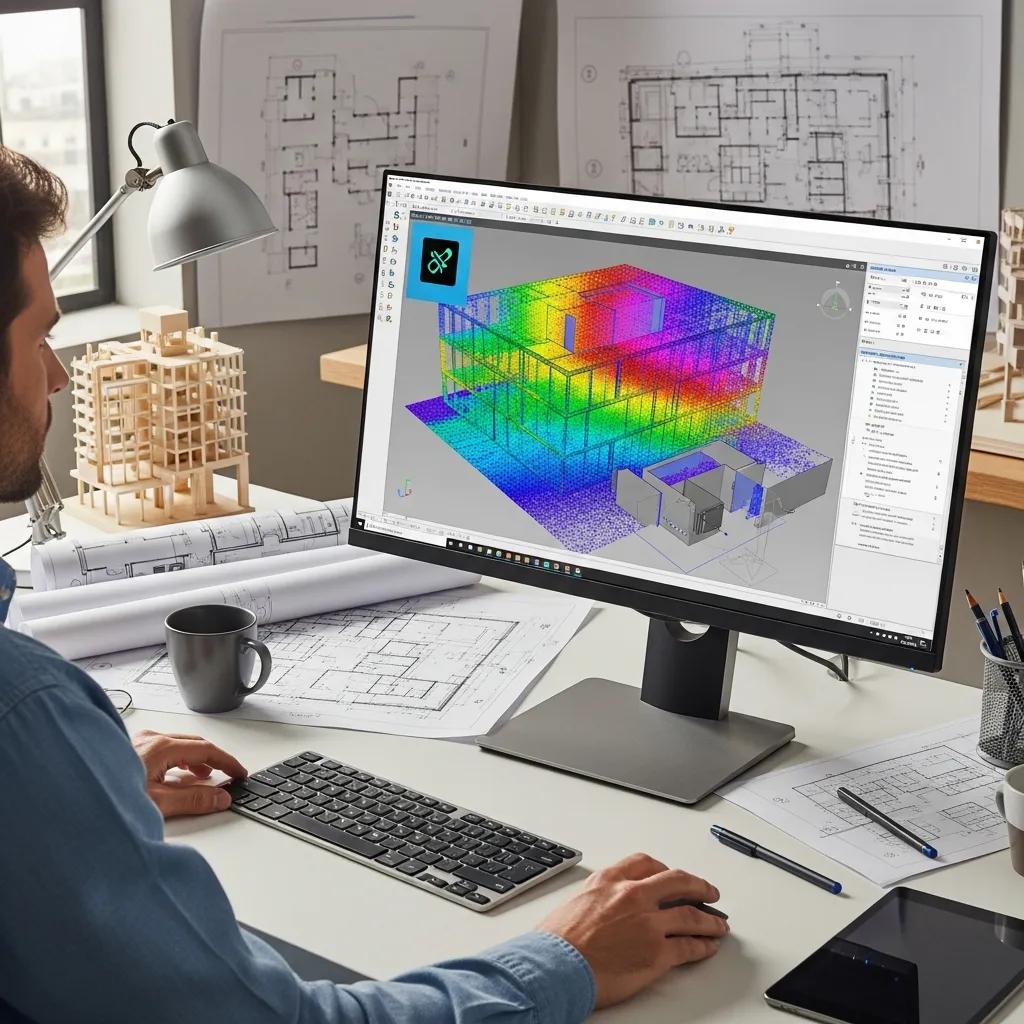
The process begins by registering multiple scan positions into a single, georeferenced dataset, then cleaning and classifying point clusters that represent walls, slabs, ductwork, and structural members. Automated feature extraction and AI-assisted segmentation speed up objectization, while experienced modelers perform manual modeling and quality checks so parametric elements meet design intent and LOD requirements. The outcome is a semantic Revit model where relationships and attributes are explicit (for example, wall → contains → opening), enabling downstream workflows like clash detection and digital-twin creation. Our pipeline balances automation with expert verification to deliver both accurate geometry and useful metadata for construction coordination and facility management.
That transformation readies the project for trade-specific modeling strategies that prioritize MEP routing accuracy and structural tolerances during coordination.
What Are the Key Benefits of Point Cloud to BIM for Tampa's Commercial and Industrial Sectors?
Point cloud to BIM produces verified as‑built models that reduce surprises and rework on site by supplying accurate spatial data for coordination and procurement. This accuracy accelerates clash detection, provides clearer fabrication guidance for MEP contractors, and shortens downtime for industrial facilities during shutdowns. Owners and facility managers gain lifecycle value through digital twins that embed asset metadata and support preventive maintenance. For Tampa’s commercial and industrial sectors, those advantages mean lower costs, tighter schedules, and improved safety during renovations and expansions.
These sector-specific gains naturally lead into the practical workflow teams follow to capture, process, and model point clouds for use in Revit and coordination platforms.
What is the Step-by-Step Workflow for Point Cloud to BIM Conversion in Tampa?
A disciplined workflow turns point-cloud capture into an actionable BIM asset: mobilize for capture, register and clean the data, extract features, model to the agreed LOD, validate with QA and clash detection, and deliver interoperable files. Each phase uses specific tools and produces defined outputs so stakeholders can track accuracy and scope. Field control and survey ties establish coordinate systems so models align with site layout and future work; modeling conventions translate point clusters into parametric elements for LOD 300–400. Following these steps reduces ambiguity downstream and smooths integration with VDC processes used by Tampa design and construction teams.
Quick reference: the table below compares core workflow steps, the tools we commonly use, and typical deliverables so project managers know what to expect at each phase.
Introductory EAV table: workflow step compared to tools and output.
| Phase | Tools / Software | Output / Deliverable |
|---|---|---|
| Field Capture | 3D laser scanners, Trimble Robotic Total Station, LiDAR drones | Registered point cloud (E57, LAS) with control |
| Point Cloud Processing | Autodesk ReCap, cloud processing tools | Cleaned, classified point cloud (noise removed) |
| BIM Modeling | Autodesk Revit, Navisworks | Discipline BIM (RVT, IFC), LOD 300–400 |
| QA & Coordination | Navisworks, clash detection tools | Clash reports, model QA sign-off |
This side‑by‑side view clarifies the role of equipment and software in delivering construction-ready BIM models and leads into discipline-specific modeling and coordination tasks.
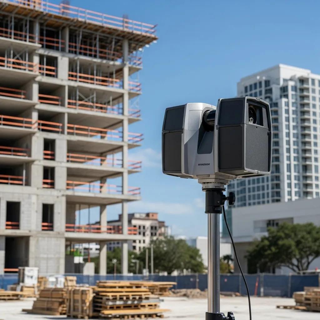
How is 3D Laser Scanning and Point Cloud Data Captured and Processed?
Capture begins with site reconnaissance and setting control using survey instruments like total stations and reference targets to ensure geospatial accuracy between scan positions. Static terrestrial scanners and, when appropriate, LiDAR drones collect dense point clouds that are registered, filtered, and colorized in processing software to create a single, consistent dataset. Processing steps include noise removal, point classification (structural, architectural, MEP), and generation of orthophotos or sections to guide modeling. Precise capture and rigorous processing reduce ambiguity and directly improve the fidelity of the resulting Revit model.
Those processing outputs feed discipline-specific modeling where classified points are translated into parametric elements for architectural, structural, and MEP use.
How are Architectural, Structural, and MEP BIM Models Created from Point Clouds?
Each discipline applies different modeling heuristics: architectural teams model walls, openings, and finishes; structural teams focus on beams, columns, and foundations; MEP teams extract conduits, ducts, and equipment with routing logic. Modelers use the processed point cloud as a tracing and verification layer, creating families and parametric objects that match geometry and attached metadata to the agreed Level of Development. Discipline models are federated for clash detection and schedule-driven sequencing. Deliverables typically include RVT, IFC, and NWC files that feed fabrication, installation, and facility-management workflows.
Once modeling is complete, teams run QA and clash detection to prepare deliverables for construction and asset handover.
Which Specialized Point Cloud to BIM Services Does CCLS Offer in Tampa, FL?
CCLS provides localized point cloud to BIM services for Tampa projects, concentrating on point-cloud rendering and model integration, plus BIM modeling and coordination to support as‑built verification and VDC workflows. Our services include architectural and structural modeling from scans, MEP extraction and coordination, and as‑built BIM for renovations and facility documentation. Common deliverables are discipline Revit models, clash detection reports, and exchange formats ready for construction and facility management, with LOD tailored to project needs.
Below is a quick matrix mapping service types to typical LOD, deliverables, and use cases for easy comparison.
| Service Type | Typical LOD / Deliverables | Typical Use-Case |
|---|---|---|
| Architectural Point Cloud to BIM | LOD 300; RVT, DWG | Tenant fit-outs, façade verification |
| Structural Point Cloud to BIM | LOD 300–350; RVT, IFC | Retrofit framing checks, load path validation |
| MEP Point Cloud to BIM & Coordination | LOD 300–400; RVT, NWC | Clash detection, prefabrication layouts |
| As-Built BIM Modeling | LOD 400; RVT, COBie-ready | Facility handover, asset management |
This service matrix shows how each offering maps to typical client needs and clarifies deliverables for procurement and coordination.
We deliver services with a client‑first approach that emphasizes precision and smooth VDC/BIM integration. Tampa teams can expect tailored scope recommendations during an initial consultation with CCLS project staff led by Nathan Conway.
What Does Architectural and Structural Point Cloud to BIM Modeling Include in Tampa Projects?
Architectural and structural conversions from point clouds generally include modeling primary building envelopes, openings, stair systems, slabs, beams, and column layouts to tolerances appropriate for LOD 300 and above. Modelers reconcile point-derived geometry with existing design documents when available and mark deviations as change markers or as‑built annotations for client review. Deliverables include tagged Revit elements, dimensional checks, and comparison reports showing measured conditions versus design. These outputs support retrofit coordination, permit submissions, and accurate fabrication of replacement components.
Clear documentation and tolerance reporting help contractors and owners make informed decisions during retrofits and structural modifications.
How Does MEP Point Cloud to BIM and As-Built BIM Modeling Support Tampa Renovations?
MEP extraction focuses on accurately tracing ductwork, piping, conduit, and equipment so coordination teams can identify clashes and plan reroutes before field installation. Modeling includes family creation, routing logic, and defined connection points that reflect existing constraints and future intent — enabling prefabrication and more predictable installation schedules. As‑built BIM delivers asset data and locations in formats facility teams can use for maintenance and O&M planning. By reducing field changes and enabling off‑site fabrication, these services shorten downtime and improve safety during phased renovations.
MEP models feed directly into clash-detection and scheduling tools to support sequencing during tight renovation windows.
How Does CCLS Leverage Advanced Technology and Expertise for Point Cloud to BIM in Tampa?

CCLS combines modern reality-capture hardware with a proven software stack to deliver construction-ready BIM for Tampa clients. Field control using Trimble Robotic Total Station anchors scans to site coordinates, while 3D laser scanners and LiDAR platforms capture dense datasets for detailed modeling. In the office, point clouds are processed and optimized, models are authored in Autodesk Revit, and Navisworks is used for federated coordination and clash detection. That blend of field precision and software interoperability helps ensure models meet LOD expectations and integrate smoothly into VDC processes.
Our technology and experience move projects from raw scan data into a managed digital environment that supports construction and facility-management handover.
What Role Do Trimble Robotic Total Station and 3D Laser Scanning Play in Ensuring Precision?
The Trimble Robotic Total Station provides survey-grade control that anchors scan positions to a consistent coordinate system, reducing registration error and ensuring layout accuracy for construction tasks. Paired with 3D laser scanning, these instruments produce point clouds with measurable tolerances suitable for installation and prefabrication. Survey-controlled capture means resulting Revit models can guide site layout crews by linking digital coordinates to field stakes and construction marks. That accuracy bridges the gap between virtual coordination and on-site execution for Tampa projects.
Survey control supports downstream QA and improves the reliability of BIM-derived quantities and fabrication documents.
Which BIM Software Tools Like Revit and Navisworks Are Used for Accurate Model Integration?
Our point-cloud-to-BIM workflow typically uses Autodesk Revit for parametric modeling, Autodesk ReCap for initial point-cloud processing, and Navisworks for federated coordination and clash detection. Revit is the authoring environment for discipline models and supports LOD tagging and metadata. ReCap prepares and optimizes point clouds for efficient modeling, and Navisworks aggregates discipline models for clash tests and schedule reviews, producing NWC/NWD outputs and clash reports that guide remediation. These tools also support export to IFC and other formats for cross-platform collaboration and facility-management integration.
Selecting the right software stack ensures models remain usable across procurement, fabrication, and long-term operations.
How Can Tampa Clients Benefit from Point Cloud to BIM Conversion Services for Their Industry Needs?
Point cloud to BIM supports industry-specific workflows by providing precise spatial data and semantically rich models that reduce risk and inform lifecycle decisions. Healthcare facilities use scan-based BIM for phased renovations and tight MEP coordination in clinical spaces. Industrial plants rely on accurate as‑built models to minimize shutdown time during rework. Commercial buildings leverage models for tenant fit-outs and vertical coordination. These applications deliver measurable ROI through fewer RFIs, reduced change orders, and clearer fabrication guidance. Mapping industries to outcomes helps project teams prioritize scan scope and LOD for the greatest business impact.
The table below maps industries to primary applications and expected outcomes so Tampa clients can align scanning investments with operational goals.
| Industry | Primary Application | Outcome / ROI Example |
|---|---|---|
| Healthcare | Phased renovations, MEP coordination | Reduced downtime during retrofits; fewer installation errors |
| Industrial / Pharma | Plant layout, shutdown planning | Shorter shutdowns; improved safety and throughput |
| Commercial | Tenant fit-outs, vertical coordination | Faster tenant occupancy; lower fit-out costs |
| Historic Preservation | Accurate as-built record, conservation planning | Durable documentation for restoration and regulatory review |
This mapping shows how point-cloud-to-BIM investments translate into operational and financial benefits across Tampa sectors.
What Are the Applications of Point Cloud to BIM in Healthcare, Industrial, and Commercial Facilities?
In healthcare, point cloud to BIM captures complex MEP systems and room geometry to plan phased renovations while minimizing disruption to clinical operations. Industrial facilities use model-derived layouts for equipment relocation and maintenance scheduling, reducing unplanned downtime and enabling precise prefabrication. Commercial projects depend on accurate existing‑conditions models to speed tenant fit-outs and coordinate architectural, structural, and MEP trades. Across these applications, BIM’s semantic richness supports immediate construction needs and long‑term asset management.
These use cases explain why project teams choose appropriate LOD and deliverables based on operational constraints and renovation phasing.
How Does Point Cloud to BIM Facilitate Facility Management and Historic Preservation in Tampa?
Point cloud to BIM creates digital twins and asset‑tagged models that integrate with O&M systems, enabling facility managers to query asset metadata, schedule maintenance, and visualize systems in context. For historic preservation, high-fidelity point clouds serve as archival records and provide dimensional accuracy for restoration, documentation, and compliance reviews. FM deliverables typically include COBie-ready metadata, tagged families, and accessible Revit models that feed CMMS platforms; preservation outputs often include measured drawings and high-resolution orthophotos. These deliverables support better decisions, preventive maintenance, and conservation across Tampa’s unique building stock.
Extending point-cloud investments into FM and preservation increases long-term operational value beyond construction.
What Are the Proven Results and How to Request a Consultation for Point Cloud to BIM in Tampa?
Measured results from point-cloud-to-BIM engagements include quantified reductions in field rework, faster coordination cycles, and improved accuracy for prefabrication and installation. Case summaries typically cite percent reductions in RFIs, shortened installation timelines, and fewer on-site change orders when models guide coordination and fabrication. Tampa teams considering point-cloud-to-BIM should expect a structured consultation that reviews scope, desired LOD, site access, and deliverable formats, followed by a proposal that clarifies timeline and acceptance criteria. That process aligns expectations and establishes measurable success metrics for the conversion.
To request a consultation, prepare project drawings, photos, and scope notes; during the initial meeting we’ll verify access, discuss survey control needs, and outline deliverables and milestones.
Which Case Studies Demonstrate CCLS’s Success in Tampa’s Point Cloud to BIM Projects?
Relevant case summaries follow a problem → solution → result format where CCLS used reality capture and BIM modeling to resolve as‑built uncertainty and coordination conflicts. Typical examples show how accurate Revit models enabled clash-free prefabrication, reduced installation hours, and delivered asset-ready models for facility teams. Results often include shorter coordination cycles and documented tolerance compliance that supported efficient construction handover. These highlights guide scoping conversations and help clients set realistic expectations for new Tampa projects.
These documented outcomes form the basis of our client discussions and inform project scoping to achieve comparable results.
How Can Tampa Construction Professionals Request Expert Point Cloud to BIM Services from CCLS?
To request services, Tampa construction professionals should prepare a brief project summary, any available drawings, and preferred deliverable formats so we can scope field capture and modeling needs accurately. The initial inquiry typically leads to a kickoff defining control requirements, capture schedule, LOD expectations, and deliverable timelines; from there we provide a proposal and statement of work with milestones and acceptance criteria. Being ready with site access details and project goals speeds engagement and helps ensure BIM deliverables meet coordination and operational needs. Prospective clients will work directly with CCLS project contacts who bring local experience and a client-centered approach to scope and delivery.
Following this structured scoping and contact process makes it straightforward for Tampa teams to secure reliable point-cloud-to-BIM services and achieve measurable construction and lifecycle outcomes.
Key project intake checklist:
- Project summary: Brief description of scope, building type, and objectives.
- Available documentation: Existing drawings, photos, or survey data.
- Desired deliverables: Preferred file types, LOD, and coordination requirements.
- Site constraints: Access windows, operational limitations, and safety notes.
This checklist speeds proposals and aligns expectations before we mobilize to the field.
Frequently Asked Questions
What types of projects benefit most from Point Cloud to BIM services in Tampa?
Point cloud to BIM is especially valuable for commercial, industrial, and healthcare projects. Commercial work gains from accurate as‑built models for tenant fit-outs and vertical coordination. Industrial sites benefit from precise layouts that reduce downtime during maintenance and rework. Healthcare projects rely on scan-based BIM for phased renovations and tight MEP coordination with minimal clinical disruption. Across sectors, clients see improved accuracy, less rework, and better lifecycle management — making point-cloud-to-BIM a high-impact investment.
How does Point Cloud to BIM improve collaboration among project stakeholders?
Point cloud to BIM creates a shared, accurate digital asset that architects, engineers, and contractors can reference, reducing misunderstandings. BIM’s semantic data helps teams visualize complex systems and catch clashes early. By federating discipline models for clash detection and schedule reviews, stakeholders coordinate more effectively, shorten revision cycles, and reduce on-site surprises.
What are the common challenges faced during Point Cloud to BIM conversion?
Common challenges include noisy or incomplete scan data, the complexity of modeling intricate systems, and meeting the agreed Level of Development (LOD). Discipline coordination can also be difficult when resolving clashes. These challenges are mitigated by a disciplined workflow, quality field control, experienced modelers, and clear communication among all project teams.
How can clients ensure the accuracy of their Point Cloud to BIM models?
Clients ensure accuracy by planning up front and setting clear LOD expectations. Use high-quality scanning equipment, apply rigorous processing techniques, and build QA steps such as validation checks and clash detection into the schedule. Regular communication with your modeling team during the project closes gaps early and delivers more reliable BIM outputs.
What role does technology play in the Point Cloud to BIM process?
Technology enables precise capture, efficient processing, and accurate modeling. Tools like 3D laser scanners and LiDAR drones create dense point clouds, while Autodesk ReCap, Revit, and Navisworks transform that data into intelligent BIM models. The right hardware and software streamline workflows, improve accuracy, and support collaboration across teams.
What should clients prepare before requesting Point Cloud to BIM services?
Before requesting services, prepare a concise project summary outlining scope, building type, and objectives. Gather any existing drawings, photos, or survey data. Specify desired deliverables, file types, and LOD expectations, and note site constraints such as access windows and operational limitations. These details help us scope work accurately and provide a focused proposal.
Conclusion
Point cloud to BIM conversion in Tampa delivers clear advantages: greater accuracy, less rework, and tighter collaboration across project teams. Converting high-density 3D laser scans into intelligent BIM models streamlines workflows and improves construction and operational outcomes. If you want to explore how this approach applies to your next project, request a consultation — we’ll walk you through scope, schedule, and expected results so you can move forward with confidence.