Precise Existing Conditions for Better Project Coordination
Accurate information is the foundation of every successful construction project.
When existing conditions are measured incorrectly or outdated drawings are used for coordination, projects can quickly experience delays, installation conflicts, rework, and unnecessary expenses. In today’s construction environment, where schedules are tight and projects are increasingly complex, reliable field data is more important than ever.
At Conway Coordination and Layout Services (CCLS), we provide professional 3D scanning services in Asheville, NC that help contractors, engineers, architects, and project managers capture accurate real-world conditions before problems impact the project.
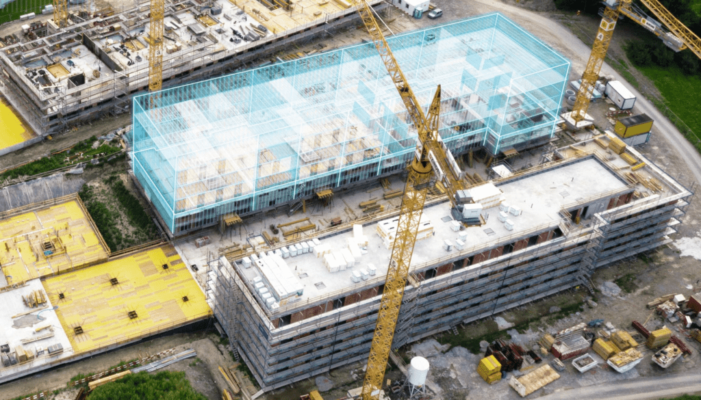
Using advanced laser scanning technology, we create highly detailed digital representations of project environments that support BIM coordination, prefabrication, planning, layout verification, and quality control.
Our goal is simple: provide dependable field information that helps construction teams reduce uncertainty, improve coordination, and build more efficiently.
What Is 3D Scanning?
3D scanning is the process of using laser-based equipment to capture millions of highly accurate measurements across buildings, structures, and active construction sites.
The collected data is converted into a digital point cloud that reflects real-world field conditions with exceptional detail.
This point cloud can then be used throughout the construction process for:
• Existing conditions documentation
• BIM and VDC coordination
• Clash detection
• Prefabrication support
• Layout verification
• Quality assurance
• As-built documentation
Rather than relying on estimated dimensions or outdated plans, project teams gain access to dependable field data captured directly from the jobsite.
This level of precision helps improve coordination and reduce costly issues throughout the project lifecycle.
Why 3D Scanning Matters in Asheville Construction
Construction projects throughout Asheville and Western North Carolina often involve unique architectural challenges, complex terrain, renovations, and technically demanding environments.
Commercial construction, healthcare facilities, hospitality projects, and institutional renovations all require accurate coordination between multiple trades and systems.
As modern construction increasingly relies on digital coordination and prefabrication, the need for accurate field information continues to grow.
Without dependable existing conditions, projects frequently encounter:
• Trade coordination conflicts
• Installation errors
• Delays and rework
• Material waste
• Increased labor costs
• Reduced project efficiency
3D scanning helps eliminate these issues by creating highly accurate digital records of existing field conditions before construction progresses.
This allows project teams to coordinate more effectively and identify potential problems before they impact schedules and budgets.
Our 3D Scanning Services
High-Precision Laser Scanning
We use advanced scanning equipment to capture millions of accurate measurements throughout project environments.
These scans create detailed digital representations of structures, layouts, and building systems.
Existing Conditions Documentation
Before renovation, retrofit, or expansion work begins, understanding the existing environment is critical.
Our scanning services provide accurate field documentation that helps reduce unforeseen construction issues.
Point Cloud Processing
We process captured scan data into point cloud files that integrate directly into BIM and VDC workflows.
This allows project teams to coordinate using accurate real-world field conditions rather than assumptions.
Verification and Quality Control
Our scanning services help verify that installations align with project specifications and design intent.
This improves quality control and helps reduce costly corrections.
Construction Progress Monitoring
Scanning throughout construction allows teams to monitor progress, compare installations, and identify discrepancies before they impact schedules.
Supporting Contractors Throughout Asheville
At CCLS, we understand the challenges associated with active construction sites and technically demanding projects.
Contractors must maintain schedules, coordinate multiple trades, and deliver accurate installations while managing changing jobsite conditions.
Our role is to provide accurate field data that supports smoother coordination and more efficient construction.
We support:
• General contractors
• Mechanical contractors
• Electrical contractors
• Plumbing contractors
• Steel fabricators and erectors
• BIM and VDC teams
• Developers and construction managers
Whether your project involves hospitality development, healthcare construction, institutional work, or commercial renovation, our scanning services provide the accurate information needed to improve project outcomes.
The Risks of Inaccurate Existing Conditions
Many construction problems begin with incomplete or inaccurate field information.
Without dependable existing conditions, projects often face:
• Installation conflicts
• Trade coordination problems
• Rework and schedule delays
• Material waste
• Increased labor costs
• Reduced productivity
These problems affect project schedules, budgets, and overall performance.
3D scanning reduces these risks by creating highly accurate digital records of existing conditions before construction progresses too far.
This clarity allows teams to make informed decisions and coordinate more effectively throughout construction.
The CCLS Difference
At CCLS, we combine advanced scanning technology with real-world construction experience.
We understand how accurate field information impacts layout, fabrication, coordination, and installation because we work directly within construction environments.
Construction-Focused Experience
Our background in layout and coordination gives us a practical understanding of active jobsite workflows.
Commitment to Precision
Accuracy is central to every scan we perform.
Dependable Project Support
We understand active construction schedules and work efficiently to support projects without disrupting progress.
Technology Built for Coordination
Our scanning outputs integrate directly into BIM and VDC workflows, helping teams coordinate more effectively.
Applications for 3D Scanning in Asheville Projects
Our services support a wide range of project types throughout Asheville and surrounding Western North Carolina markets.
Commercial Construction
Verify layouts, structural conditions, and installation accuracy before construction progresses.
Hospitality and Resort Projects
Capture detailed field conditions within hotels, resorts, and entertainment spaces.
Healthcare Facilities
Document technically demanding environments where precise coordination is critical.
Institutional and Educational Buildings
Support renovations, expansions, and complex coordination requirements.
Renovations and Historic Structures
Capture accurate existing conditions before demolition or upgrades begin.
Prefabrication Support
Provide precise measurements that improve fabrication accuracy and installation efficiency.
Supporting the Full Construction Lifecycle
3D scanning creates value throughout every stage of construction.
Pre-Construction Planning
Capture existing conditions for planning, coordination, and design.
During Construction
Verify installations, monitor progress, and identify issues before they affect schedules.
Post-Construction Documentation
Provide accurate as-built documentation for facility management and future renovations.
Why Precision Matters in Modern Construction
Modern construction depends heavily on coordination between multiple trades, systems, schedules, and digital workflows.
As projects continue to increase in complexity, dependable field information becomes one of the most valuable tools available to contractors and project teams.
3D scanning helps eliminate uncertainty by providing accurate project data that supports better planning, improved coordination, and more efficient execution.
For contractors throughout Asheville, that level of precision can significantly improve project performance and reduce costly issues.
Why Asheville Contractors Choose CCLS
Contractors choose CCLS because we understand both advanced technology and real-world construction operations.
Our clients trust us because:
• We provide accurate and dependable field data
• We understand active construction workflows
• We work efficiently on busy jobsites
• We communicate clearly throughout projects
• We focus on helping projects stay coordinated and on schedule
Our commitment to precision helps construction teams work with greater confidence and efficiency.
Service Area
This page is focused on our 3D scanning services in Asheville, NC, but we also support projects throughout:
Charlotte, Raleigh, Wilmington, Greenville NC, Siler City, Charleston, Myrtle Beach, Greenville SC, Greer, Clemson, and Spartanburg.
Get Started with 3D Scanning in Asheville, NC
If your project depends on accurate field conditions, improved coordination, and reduced construction risk, professional 3D scanning can help your team avoid costly issues and improve efficiency.
Whether you’re coordinating multiple trades, supporting prefabrication workflows, or documenting existing conditions, CCLS provides the accurate field data needed for successful construction outcomes.
📞 Call Now: (843) 283-4618
Explore Related Programs:
C